Pangea’s history

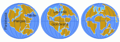
Pangea, that means ”all lands”(The term began being used in the early 20th century after Alfred Wegener noticed that the Earth’s continents looked like they fit together like a jigsaw puzzle. He later developed his theory of continental drift to explain why the continents looked the way they did and first used the term Pangea at a symposium in 1927 focused on that topic), was a supercontinent that existed on the Earth millions of years ago and covered about one-third of its surface. A supercontinent is a very large landmass that is made up of more than one continent. In the case of Pangea nearly all of the Earth’s continents were connected into one large landmass. It is believed that Pangea began forming about 300 million years ago, was fully together by 270 million years ago and began to separate around 200 million years ago.

Image

Due to mantle convection within the Earth’s surface new material constantly comes up between the Earth’s  tectonic plates at rift zones, causing them to move away from the rift and toward one another at the ends. In the case of Pangea, the Earth’s continents were eventually moved so much over millions of years that they combined into one large supercontinent.

Around 300 million years ago the northwestern part of the ancient continent of Gondwana (near the South Pole), collided with the southern part of the Euramerican continent to form one very large continent. Eventually the Angaran continent, located near the North Pole, began to move south and it collided with the northern part of the Euramerican continent to form the large supercontinent, Pangea, by about 270 million years ago.

It should be noted however that there was another separate landmass, Cathaysia, which was made up of north and south China that was not a part of the larger Pangea landmass.

Once it was completely formed, Pangea covered around one-third of the Earth’s surface and it was surrounded by an ocean that covered the rest of the globe. This ocean was called Panthalassa.

Pangea began to break up about 200 million years ago as a result of the movement of the Earth’s tectonic plates and mantle convection. Just as Pangea was formed by being pushed together due to the movement of the Earth’s plates away at rift zones, a rift of new material caused it to separate. Scientists believe that the new rift began due to a weakness in the Earth’s crust. At that weak area, magma began to push through and create a volcanic rift zone. Eventually the rift zone grew so large that it formed a basin and Pangea began to separate.

In the areas where Pangea began to separate, new oceans formed as Panthalassa rushed into the newly opened areas. The first new oceans to form were the central and southern Atlantic. About 180 million years ago the central Atlantic Ocean opened up between North America and northwestern Africa. Around 140 million years ago the South Atlantic Ocean formed when what is today South America separated from the west coast of southern Africa. The Indian Ocean was the next to form when India separated from Antarctica and Australia and about 80 million years ago North America and Europe separated, Australia and Antarctica separated and India and Madagascar separated. Over millions more years, the continents gradually moved to their current positions.

Image

s Alfred Wegener noticed in the early 20th century, the Earth’s continents seem to fit together like a jigsaw puzzle in many areas around the globe. This is the significant evidence for the existence of Pangea millions of years ago. The most prominent place where this is visible is the northwestern coast of Africa and the eastern coast of South America. In that location the two continents look like they were once connected, which they in fact were during Pangea.

Other evidence for Pangea includes fossil distribution, distinctive patterns in rock strata in now unconnected parts of the world and the distribution of the world’s coal. In terms of fossil distribution, archaeologists have found matching fossil remains if ancient species in continents are separated by thousands of miles of ocean today. For example matching reptile fossils have been found in Africa and South America indicating that these species at one time lived very close to each other as it is not possible to them to have crossed the Atlantic Ocean.

Patterns in rock strata are another indicator for the existence of Pangea. Geologists have discovered distinctive patterns in rocks in continents that are now thousands of miles apart. By having matching patterns it indicates that the two continents and their rocks were at one time one continent.

Finally the world’s coal distribution is evidence for Pangea. Coal normally forms in warm, wet climates. However geologists have found coal under Antarctica’s very cold and dry ice caps. If Antarctica were a part of Pangea it is likely that it would have been in another location on the Earth and the climate when the coal formed would have been very different than it is today.

REAL CASES OF EARTHQUAKES

After these weeks talking about geology in class, we know what an earthquake is. Well,
ifyou don´t know it, an earthquke is the result of a sudden release os energy in the Earth’s
crust that creates seismic waves. To know a little bit more about this geological
phenomenon, we will explain some real cases.


  •  JAPAN: 

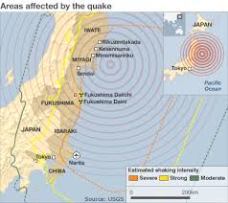
In 2011, there was an earthquake in Japan. It was the most powerful earthquake ever
recorded in Japan and the fifth in the world with a magnitude of 9.0 Mw. The epicentre of
the earthquake was around 70 Km east of the Oshika peninsula, and the hipocentre 30 Km
depth underground.

                                             Imagen

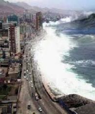
But this wasn’t the worst. After the earthquake the bad dream came and brought a powerful
tsunami with waves of 40 m high. It was such powerful that moved the main island of Japan
2.4m east and the axis of the Earth 10 cm.

                                           Imagen
Human and material lost were unbeliable: 15885 depths, 6148 injuried, 2623 missed, more
than a million buildings collapsed…


  •  HAITI: 

In 2010, there was another catastrophic earthquake, but in Haiti with a magnitude of 7.0
Mw. The epicentre was 15 Km from the capital, Port au Prince, and the hipocentre, 10 Km
underground. There was also a tsunami later, but it didn’t cause really important problems.
The effects over this contry after the eartquake were horrible. Last news say that 316000
people died, 350000 got injured and more than 1.5 million people ran out of home.

Imagen

This two extremley cases are also totally different. The earthquake in Japan was more
powerful, but the one in Haiti was more destructive. This is because as Japan is placed in a
region where three ectonic plates meet and a lot of eartquakes eccur there, people have
built their houses with a really high technology to support the Earth’s movements. But in
this case, the problem was the tsunami. Although, in Haiti, the most poor country in
America, people don’t have adapted buildings so most of them crushed inmediatly because
of the earthquake. But the tsunami later, didn’t cause really important damages because
they had done.

POSTED BY: Silvia and Carla

Harry Hammond Hess

Harry Hammond Hess: One of the Discoverers of Seafloor Spreading


Harry Hess

Harry Hammond Hess (1906 – 1969)
 

Harry Hess was a professor of geology at Princeton University (USA), and became interested in the geology of the oceans while serving in the US Navy in World War II. His time as a Navy officer was an opportunity to use sonar (also called echo sounding), then a new technology, to map the ocean floor across the North Pacific.

He published ‘The History of Ocean Basins‘ in 1962, in which he outlined a theory that could explain how the continents could actually drift. This theory later became known as ‘Sea Floor Spreading‘.

Hess discovered that the oceans were shallower in the middle and identified the presence of Mid Ocean Ridges, raised above the surrounding generally flat sea floor (abyssal plain) by as much as 1.5 km. In addition he found that the deepest parts of the oceans were very close to continental margins in the Pacific with Ocean Trenches extending down to depths of over 11 km in the case of the Marianas Trench off the coast of Japan.

Hess envisaged that oceans grew from their centres, with molten material (basalt) oozing up from the Earth’s mantle along the mid ocean ridges. This created new seafloor which then spread away from the ridge in both directions. The ocean ridge was thermally expanded and consequently higher than the ocean floor further away. As spreading continued, the older ocean floor cooled and subsided to the level of the abyssal plain which is approximately 4 km deep.

Hess believed that ocean trenches were the locations where ocean floor was destroyed and recycled.

Although his theory made sense, Hess knew, like Wegener, that he still needed convincing geophysical evidence to support it. This was to come just a year after his 1962 publication…

  • Hess theorized that the ocean floor is at most only a few hundred million years old, significantly younger than the continents. This is how long it takes for molten rock to ooze up from volcanically active mid-ocean ridges, spread sideways to create new seafloor, and disappear back into the Earth’s deep interior at the ocean trenches. This “recycling” process, later named “seafloor spreading,” carries off older sediment and fossils, and moves the continents as new ocean crust spreads away from the ridges.


  • Supporting Wegener’s theory of continental drift, Hess explained how the once-joined continents had separated into the seven that exist today. The continents don’t change dramatically or move independently, but are transported by the shifting tectonic plates on which they rest.


  • Hess’s bold intuition was subsequently corroborated. Later studies showed that the age of the ocean floor increases with distance from the ridge crests, and seismic studies confirmed that the oceanic crust was indeed sinking into the trenches. His report, History of Ocean Basins, was formally published in 1962 and for some time was the single most referenced work in solid-earth geophysics.


  • Hess also contributed significantly to his university, where he became head of the Princeton geology department, and was an important member of the national scientific community. He helped design the national space program, and was one of ten members of a panel appointed to analyze rock samples brought back from the Moon by the Apollo 11 crew. He died in August, 1969, a month after Apollo 11’s successful mission. A National Academy of Sciences memoir calls Hess “one of the truly remarkable earth scientists of this centur

The Mid-Atlantic Ridge

The Atlantic Ocean is the second-largest of the world’s oceans divisions. With a total area of about 106,400,000 square kilometres (41,100,000 sq mi), it covers approximately 20 percent of the Earth’s surface. The first part of its name refers to Atlas of Greek mythology, making the Atlantic the “Sea of Atlas.”

The above map shows the depths. The darker the color, the deeper the area. The average depth of the Atlantic is 12,880 feet (3,926 m). The greatest depth is the Milwaukee Deep at 27,500 feet (8,380 m), which is in the Puerto Rico Trench. The Atlantic’s width varies from 1,770 miles (2,848 km) between Brazil and Sierra Leone to over 4,000 miles (6,400 km) in the south. There are 93 countries that border the ocean including 16 in Europe, 27 in Africa, 11 in South America, 27 in the Caribbean, and 12 in Central and North America.

The principal feature of the Atlantic Ocean’s bottom topography is a submarine mountain range called the Mid-Atlantic Ridge.

It extends from Iceland in the north to approximately 58° South latitude, reaching a maximum width of about 990 miles (1,590 km). A great rift valley also extends along the ridge over most of its length.

The depth of water at the apex of the ridge is less than 8,900 ft (2,700 m) in most places, while the bottom of the ridge is three times as deep averaging between 12,000 and 18,000 feet (3,700 – 5,500 m).

Several peaks rise above the water and form islands. A ridge under the Atlantic Ocean was first inferred by Matthew Fontaine Maury in 1850.

The ridge was discovered during the expedition of HMS Challenger in 1872.

A team of scientists on board, led by Charles Wyville Thomson, discovered a large rise in the middle of the Atlantic while investigating the future location for a transatlantic telegraph cable.

The Atlantic Ocean formed due to sea floor spreading and plate tectonic motion which split the previous supercontinent Pangea around 180 million years ago. Pangea is shown below as is the topography of the Mid-Atlantic ridge.


HISTORY:
 
The Atlantic Ocean was the first ocean to be crossed by both boat and plane. In the year 1000, the Icelander Leif Ericson was the first European to set foot on North American soil, corresponding to today’s Eastern coast of Canada.
In 1492, Christopher Columbus (shown below) landed on the island of San Salvador in The Bahamas.
 
The first successful telegraph cable was laid under Atlantic Ocean in 1866. In 1921, the British were the first to cross the North Atlantic in an airship.
In 1927, Charles Lindbergh made the first solo non-stop transatlantic flight in an aircraft (between New York City and Paris). In 1932, Amelia Earhart became the first female to make a solo flight across the Atlantic.

A few photos of life forms found along the Mid-Atlantic ridge: